)
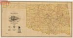
Home-Seekers Mecca Map - 1889
H.C. Townsend, General Passenger and Ticket Agent
$10.00
Home-Seeker’s Mecca Map - 1889 is a correct map of the Oklahoma Country and Cherokee Outlet reached via the Missouri Pacific Railway and Iron Mountain Route. The map was created by H.C. Townsend, General Passenger and Ticket Agent of the Missouri Pacific Railway, St. Louis, Missouri (HISMAP.0053).