)
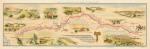
Texas Cattle Trail Map
Oklahoma State Highway Commission, 1933
$10.00
Texas Cattle Trail Map, also called the Western Cattle Trail, the Abilene & Ft. Dodge Trail, the Ft. Griffin-Ft. Dodge Trail and/or the Dodge City trail. Throughout the second half of the nineteenth century Texas cattlemen sought routes to trail their herds to northern markets. As the line of settlements moved westward, the trails that served cattlemen were closed. First the Shawnee Trail and then the Chisholm Trail became unusable. In 1874 John T. Lytle blazed a new path beyond the western edge of settlement, stretching from the grazing ranges of Texas to Fort Robinson, Nebraska. When the U.S. Army successfully concluded the Red River War in early 1875, driving the Comanche and Kiowa onto a reservation, Lytle's trail became the most popular path to the railheads in Kansas and Nebraska. It remained the most used until the cattle trailing industry ended in the 1890s(HISMAP.0003).