Contact Us | Press Room

Oklahoma Historical Society - Collect, Preserve, Share Skip to Content
  • Oklahoma History Center
    • About OHC
    • Visitor Info
    • Exhibits
    • Classes & Events
    • Education
    • Facility Use
    • Blog
    • CafĂ©
    • Shop
    • Contact Us
    • More...
  • Research Center
    • Oklahoma Resources
    • Genealogy
    • Records
    • Books
    • Indian Records
    • Photographs
    • Manuscripts
    • Newspapers
    • Maps
    • Oral Histories
    • Film & Video
    • Orders & Fees
    • Search Catalog
    • More...
  • Museums and Sites
    • Museums
    • Historic Homes
    • Military Sites
    • Affiliates
    • Historic Markers
    • More...
  • State Historic Preservation Office
    • National Register
    • Section 106
    • Tax Credits
    • Farm & Ranch
    • Special Events
    • HPRC
    • SHPO Staff
    • More...
  • Publications
    • Chronicles of Oklahoma
    • Encyclopedia
    • Books in Print
    • More...
  • About
    • History
    • Podcasts
    • Annual Meeting
    • OHS Extra! Newsletter
    • Board of Directors
    • Jobs Opportunities
    • Contact Us
    • Press Room
    • More...
  • Learn
  • Calendar
  • Support
    • Membership
    • Giving
    • Annual Giving
    • Naming Opportunities
    • Endowment/Planned Giving
    • Monogrammed Brick Locator
    • Volunteer
    • More...
none
Home > Store > Maps > Historic Maps > Raymer Map, Early...
Sign In or Register | View Cart | Checkout
Raymer Map, Early 1900s

Raymer Map, Early 1900s: 24'' X 36'' and 11''X14'' Prints

$10.00

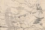
This hand drawn map was crafted by Oklahoman Lester Raymer of Alva. In 1939 the Daughters of the American Revolution, who commissioned the work, donated the map to the Oklahoma Historical Society. On the map Raymer estimated the location of many historic sites, battles, roadways, and exploration routes.

Another cool thing about the map is that it was donated along with a painting by Mrs. Louise Fluke. That painting would be used to design the state flag of Oklahoma (below is the description of the two donations).

At a meeting of representatives of the Oklahoma Society of the Daughters of the American Revolution at the Historical Building on May 10, Mrs. Frank Gordon Munson, Alva, state historian of the D. A. R., told members about the celebration being planned to commemorate Coronado's passing through Oklahoma. On behalf of the state society she presented to the Oklahoma Historical Society the following: A frame containing the Oklahoma state flag painted and described by Mrs. Louise F. Fluke of Ponca City; a historical map of Oklahoma drawn by Lester W. Raymer of Alva, and a frame enclosing the object, creed, pledge, and belief of the National Society of the D. A. R., prepared by Mrs. Fluke.- The Chronicles of Oklahoma Volume 17, No. 3 September, 1939.

(Image #Hismap.0001)


You might also like...

Texas Cattle Trail Map
$10.00
1890 Oklahoma and Indian Territory
1890 Oklahoma and Indian Territory: 19'' x 26'' Print
$10.00
Cruisin' Oklahoma Route 66
$10.00
Blue Raymer Map, Early 1900s
$10.00
  • Store
  • What's New
  • Books
  • Maps
  • Mouse Pads
  • Photographs
  • Playing Cards
  • Puzzles
  • Research Orders
Contact the Store
Shipping Policies
Research Request Policies

Oklahoma History Center 800 Nazih Zuhdi Drive, Oklahoma City, OK 73105
Site Index | Contact Us | Privacy