)
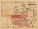
Military Map of the United States & Territories - 1861
Published by P.S. Duval and Son 1861
$10.00
Military map of the United States & territories showing the location of the military posts, arsenals, Navy Yards, & ports of entry. Compiled from 1861. Library of Congress Geography and Map Division Washington, D.C. Map includes state capitals and principal towns, drainage, geographic coordinates, and names and boundaries of the states and territories.