Contact Us | Press Room

Oklahoma Historical Society - Collect, Preserve, Share Skip to Content
  • Oklahoma History Center
    • About OHC
    • Visitor Info
    • Exhibits
    • Classes & Events
    • Education
    • Facility Use
    • Blog
    • CafĂ©
    • Shop
    • Contact Us
    • More...
  • Research Center
    • Oklahoma Resources
    • Genealogy
    • Records
    • Books
    • Indian Records
    • Photographs
    • Manuscripts
    • Newspapers
    • Maps
    • Oral Histories
    • Film & Video
    • Orders & Fees
    • Search Catalog
    • More...
  • Museums and Sites
    • Museums
    • Historic Homes
    • Military Sites
    • Affiliates
    • Historic Markers
    • More...
  • State Historic Preservation Office
    • National Register
    • Section 106
    • Tax Credits
    • Farm & Ranch
    • Special Events
    • HPRC
    • SHPO Staff
    • More...
  • Publications
    • Chronicles of Oklahoma
    • Encyclopedia
    • Books in Print
    • More...
  • About
    • History
    • Podcasts
    • Annual Meeting
    • OHS Extra! Newsletter
    • Board of Directors
    • Jobs Opportunities
    • Contact Us
    • Press Room
    • More...
  • Learn
  • Calendar
  • Support
    • Membership
    • Giving
    • Annual Giving
    • Naming Opportunities
    • Endowment/Planned Giving
    • Monogrammed Brick Locator
    • Volunteer
    • More...
none
Home > Store > Maps > Historic Maps > 1890 Oklahoma and...
Sign In or Register | View Cart | Checkout
1890 Oklahoma and Indian Territory

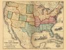
1890 Oklahoma and Indian Territory: 19'' x 26'' Print

$10.00

Removed from a volume of the 11th Census of the U.S titled “Indians Taxed and Not Taxed”, dealing with statistical and historical information from the census regarding the Indians. Has a list of railroads authorized by Congress to be built in the Indian Territory and Oklahoma, statistics on the Indian populations and land holdings.


You might also like...

Map of the City of El Reno, Canadian County, Oklahoma Territory, 1891
$10.00
Indian Territory, Prior to 1889
Indian Territory, Prior to 1889: 18'' X 24'' Print
$10.00
Blue Raymer Map, Early 1900s
$10.00
Raymer Map, Early 1900s
Raymer Map, Early 1900s: 24'' X 36'' and 11''X14'' Prints
$10.00
  • Store
  • What's New
  • Books
  • Maps
  • Mouse Pads
  • Photographs
  • Playing Cards
  • Puzzles
  • Research Orders
Contact the Store
Shipping Policies
Research Request Policies

Oklahoma History Center 800 Nazih Zuhdi Drive, Oklahoma City, OK 73105
Site Index | Contact Us | Privacy