)
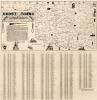
Cherokee Strip Map, 1884
$10.00
The Cherokee Strip map, 1884 illustrates land that was once leased by the Cherokee Strip Live Stock Association from the Cherokee Nation. Showing locations of ranches, camps and range lines in the IT (ITMAP.0166). Formed March 7, 1883, at Caldwell, Kansas, by Kansas ranchers to regulate roundups, to keep a record of members brands, and to resolve the issue of stray cattle, the Cherokee Strip Live Stock Association provided order and organization to cattle ranchers throughout the Cherokee Strip. Located in northwestern Indian Territory, the Cherokee Strip extended from the 96th Meridian to the 100th Meridian. A belt of land sixty miles wide containing more than 6.5 million acres, this area became the cattleman's last frontier in a fast-changing era that saw the rise and fall of the open-range cattle industry. The association promoted the interest of cattlemen located in the former Cherokee Strip in southern Kansas and in the Cherokee Outlet in northwestern Oklahoma. The Cherokee Strip Live Stock Association carried out its duties, improving cattle breeds and providing an organized lobbying group to restrain the throngs of homesteaders in Kansas, eager to lay claim to lands in the strip. The association found an ally and mutual friend in the Cherokee Nation but was strongly opposed by homesteaders and the U.S. government. Eventually succumbing to the effects of harsh weather conditions in 1886–87 and the eventual sale of the Cherokee Outlet to the federal government in 1891, the Cherokee Strip Live Stock Association ended in 1893.