Contact Us
|
Press Room
Skip to Content
Oklahoma History Center
About OHC
Visitor Info
Exhibits
Classes & Events
Education
Facility Use
Blog
Café
Shop
Contact Us
More...
Research Center
Oklahoma Resources
Genealogy
Records
Books
Indian Records
Photographs
Manuscripts
Newspapers
Maps
Oral Histories
Film & Video
Orders & Fees
Search Catalog
More...
Museums & Sites
Museums
Historic Homes
Military Sites
Affiliates
Historic Markers
More...
State Historic Preservation Office
National Register
Section 106
Tax Credits
Farm & Ranch
Special Events
HPRC
SHPO Staff
More...
Publications
Chronicles of Oklahoma
Encyclopedia
Books in Print
More...
About
History
Podcasts
Annual Meeting
OHS Extra! Newsletter
Board of Directors
Jobs Opportunities
Contact Us
Press Room
More...
Education
Calendar
Support OHS
Membership
Giving
Annual Giving
Naming Opportunities
Endowment/Planned Giving
Monogrammed Brick Locator
Volunteer
More...
Home
>
Store
>
Maps
>
Historic Maps
> Indian Territory ...
Sign In
or
Register
|
View Cart
|
Checkout
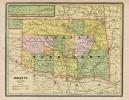
Indian Territory Map - 1892
Rand McNally and Company
$10.00
1892 Map of the Indian and Oklahoma Territory (G4021.E1 1892 .M2 TIL).
*
Sizes
- Please Select -
27'' x 34''
You might also like...
Oklahoma State Capitol - 100th Anniversary
$10.00
U.S. Indian Reservations 1893: 26'' x 19''
$10.00
1889 Broadside: 9'' x 24''
$10.00
Cherokee Strip Map, 1884
$10.00
Store
What's New
Maps
Photographs
Playing Cards
Puzzles
Research Orders