Contact Us | Press Room

Oklahoma Historical Society - Collect, Preserve, Share Skip to Content
  • Oklahoma History Center
    • About OHC
    • Visitor Info
    • Exhibits
    • Classes & Events
    • Education
    • Facility Use
    • Blog
    • CafĂ©
    • Shop
    • Contact Us
    • More...
  • Research Center
    • Oklahoma Resources
    • Genealogy
    • Records
    • Books
    • Indian Records
    • Photographs
    • Manuscripts
    • Newspapers
    • Maps
    • Oral Histories
    • Film & Video
    • Orders & Fees
    • Search Catalog
    • More...
  • Museums and Sites
    • Museums
    • Historic Homes
    • Military Sites
    • Affiliates
    • Historic Markers
    • More...
  • State Historic Preservation Office
    • National Register
    • Section 106
    • Tax Credits
    • Farm & Ranch
    • Special Events
    • HPRC
    • SHPO Staff
    • More...
  • Publications
    • Chronicles of Oklahoma
    • Encyclopedia
    • Books in Print
    • More...
  • About
    • History
    • Podcasts
    • Annual Meeting
    • OHS Extra! Newsletter
    • Board of Directors
    • Jobs Opportunities
    • Contact Us
    • Press Room
    • More...
  • Learn
  • Calendar
  • Support
    • Membership
    • Giving
    • Annual Giving
    • Naming Opportunities
    • Endowment/Planned Giving
    • Monogrammed Brick Locator
    • Volunteer
    • More...
none
Home > Store > Maps > Historic Maps > Indian Territory,...
Sign In or Register | View Cart | Checkout
Indian Territory, Prior to 1889

Indian Territory, Prior to 1889: 18'' X 24'' Print

$10.00

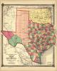
Prior to non-Indian settlement, through land runs and lotteries, American Indian nations and tribes divided most of present Oklahoma. Interestingly, this map shows the 'Public Lands' of the future Oklahoma Panhandle, 'Oklahoma Country' or the Unassigned Lands, which were opened in the first land run, and 'Greer County,' a source of contention between Texas and the present Sooner state.(Itmap.0035)


You might also like...

Indian Territory During the 1889 Land Run
$10.00
1912 Oklahoma State Fair Poster
$10.00
First official State of Oklahoma Map, 1907 (large)
First official State of Oklahoma Map, 1907 (large): 18'' X 34'' Print
$10.00
Raymer Map, Early 1900s
Raymer Map, Early 1900s: 24'' X 36'' and 11''X14'' Prints
$10.00
  • Store
  • What's New
  • Books
  • Maps
  • Mouse Pads
  • Photographs
  • Playing Cards
  • Puzzles
  • Research Orders
Contact the Store
Shipping Policies
Research Request Policies

Oklahoma History Center 800 Nazih Zuhdi Drive, Oklahoma City, OK 73105
Site Index | Contact Us | Privacy