)
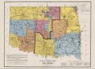
Oklahoma's Butterfield Trail Map, 1858 - 1861
$10.00
The U.S. mail was carried through Oklahoma by the Butterfield Company for only a brief period, 1858–61, but the trail it followed became famous as a western transportation route. At the end of the war with Mexico in 1848, the development of the western territories and California necessitated a means of speedy communication across the midsection of the United States. Because there was no transcontinental telegraph until 1861 or railroad until 1869, various companies developed overland stage lines and mail service between 1848 and 1869. In mid-1861 the Civil War began, interrupting the transmission of mail across Indian Territory. As a result, Butterfield shifted his operations to his northern routes. After the war ended, the 1869 completion of the transcontinental railroad spelled the end of transcontinental overland mail operations. The trail came to an end as a national thoroughfare, although local residents continued to use it as a wagon road. In 1957 Oklahoma joined with the National Committee on Overland Mails in commemorating the service's one hundredth anniversary. The observance coincided with the Oklahoma Semicentennial exposition, during which in June and July 1957 an exhibit discussed the history of this important transportation development for the state and the nation (HISMAP.0034).