)
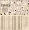
Map of the City of El Reno, Canadian County, Oklahoma Territory, 1891
$10.00
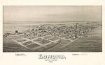
El Reno was known as the hub of Oklahoma Territory and the gateway and distributing supply point for the Cheyenne & Arapahos Nations.
El Reno originated shortly after the 1889 land run. The town's name was partially taken from the nearby military post of Fort Reno, the "el" being
added to differentiate the community from the also-new Reno City, lying was five miles northeast of El Reno.