Contact Us | Press Room

Oklahoma Historical Society - Collect, Preserve, Share Skip to Content
  • Oklahoma History Center
    • About OHC
    • Visitor Info
    • Exhibits
    • Classes & Events
    • Education
    • Facility Use
    • Blog
    • CafĂ©
    • Shop
    • Contact Us
    • More...
  • Research Center
    • Oklahoma Resources
    • Genealogy
    • Records
    • Books
    • Indian Records
    • Photographs
    • Manuscripts
    • Newspapers
    • Maps
    • Oral Histories
    • Film & Video
    • Orders & Fees
    • Search Catalog
    • More...
  • Museums and Sites
    • Museums
    • Historic Homes
    • Military Sites
    • Affiliates
    • Historic Markers
    • More...
  • State Historic Preservation Office
    • National Register
    • Section 106
    • Tax Credits
    • Farm & Ranch
    • Special Events
    • HPRC
    • SHPO Staff
    • More...
  • Publications
    • Chronicles of Oklahoma
    • Encyclopedia
    • Books in Print
    • More...
  • About
    • History
    • Podcasts
    • Annual Meeting
    • OHS Extra! Newsletter
    • Board of Directors
    • Jobs Opportunities
    • Contact Us
    • Press Room
    • More...
  • Learn
  • Calendar
  • Support
    • Membership
    • Giving
    • Annual Giving
    • Naming Opportunities
    • Endowment/Planned Giving
    • Monogrammed Brick Locator
    • Volunteer
    • More...
none
Home > Store > Maps > Historic Maps > 1889 Wiggins' Map...
Sign In or Register | View Cart | Checkout
1889 Wiggins' Map of Oklahoma Territory

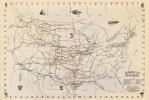
1889 Wiggins' Map of Oklahoma Territory: 26'' x 19''

$10.00

This map details railroad routes from Wichita, Kansas, into the Cherokee Outlet and Indian Territory. It includes six images of prominent Oklahomans, including William Matthewson (known in Kansas as Buffalo Bill), E. C. Cole (President of Cole’s Colony), Gordon Lillie (Pawnee Bill), George E. Harris (President of first Oklahoma Town), David L. Payne, and Harry Hill (Payne’s Chief scout).Also, this map describes the lands available thru the Springer Act.


You might also like...

Time Indicator with the Territory of Lincoln
$10.00
Oklahoma's Butterfield Trail Map, 1858 - 1861
$10.00
Oklahoma City Birds-Eye View, 1890
Oklahoma City Birds-Eye View, 1890: 16'' X 28'' Print
$10.00
Ghost Towns of Oklahoma
$10.00
  • Store
  • What's New
  • Books
  • Maps
  • Mouse Pads
  • Photographs
  • Playing Cards
  • Puzzles
  • Research Orders
Contact the Store
Shipping Policies
Research Request Policies

Oklahoma History Center 800 Nazih Zuhdi Drive, Oklahoma City, OK 73105
Site Index | Contact Us | Privacy