)
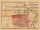
Time Indicator with the Territory of Lincoln: 24'' x 36''
$10.00
This 1864 map of the United States was created toward the end of the American Civil War, and identifies the current state of Oklahoma as the Territory-State of “Lincoln.” After the war, some lobbied for an All-Black state, similar to efforts by American Indians to have Indian Territory become the state of Sequoyah.