)
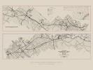
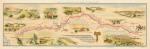
Americas Cattle Trails Map, 1949
$10.00
America’s Cattle Trails Map, 1949 showing cattle trails throughout the United States from 1540-1895 (HISMAP.0052). Immediately following the Civil War the era of the great cattle drives from Texas began. After an initial and discouraging attempt to deliver cattle to Sedalia, Missouri, in 1866, the northern migration of cattle began in earnest with the opening of the shipping center at Abilene, Kansas, in early September 1867. Oklahoma, lying between the vast cattle ranges of Texas and the colorful cow towns of Kansas and Nebraska, was crossed by the two major stock routes of the Old West, the Chisholm Trail and the Western Trail, thus contributing not only materially to the economic boom of the cattle drives but also mythically to the creation of America's greatest folk hero, the cowboy. Most of the cattle herds crossed Indian Territory at a leisurely pace, grazing on both public and Indian lands, sometimes paying a toll on the latter for grazing permits. Cattle on both trails crossed and grazed on the Cherokee Outlet, a six-million-acre strip of good grass extending some 150 miles east to west and sixty miles north to south. It had been granted to the Cherokee as an outlet to the buffalo hunting regions on the plains. Toward the latter end of the trail-drive era (roughly 1866 to 1886), cattle raisers from both Texas and Kansas began negotiations with the Cherokee Nation to place cattle legally on the Outlet. Historian Edward Everett Dale has called the Cherokee Strip Live Stock Association, loosely organized in 1880 and more formally structured in 1883, the greatest livestock organization in the world during its ten-year existence. Despite the wishes of both cattlemen and Cherokee officials, the U.S. government ordered the removal of cattle in order to open the Outlet for white settlement, culminating in the great Cherokee Outlet Opening of 1893. As in the rest of the central plains, the range-cattle era in Indian Territory was brief. In 1895 the open range was declared closed by the territorial legislature, and by the first year of the new century almost all Indian lands had been settled.