Contact Us | Press Room

Oklahoma Historical Society - Collect, Preserve, Share Skip to Content
  • Oklahoma History Center
    • About OHC
    • Visitor Info
    • Exhibits
    • Classes & Events
    • Education
    • Facility Use
    • Blog
    • CafĂ©
    • Shop
    • Contact Us
    • More...
  • Research Center
    • Oklahoma Resources
    • Genealogy
    • Records
    • Books
    • Indian Records
    • Photographs
    • Manuscripts
    • Newspapers
    • Maps
    • Oral Histories
    • Film & Video
    • Orders & Fees
    • Search Catalog
    • More...
  • Museums and Sites
    • Museums
    • Historic Homes
    • Military Sites
    • Affiliates
    • Historic Markers
    • More...
  • State Historic Preservation Office
    • National Register
    • Section 106
    • Tax Credits
    • Farm & Ranch
    • Special Events
    • HPRC
    • SHPO Staff
    • More...
  • Publications
    • Chronicles of Oklahoma
    • Encyclopedia
    • Books in Print
    • More...
  • About
    • History
    • Podcasts
    • Annual Meeting
    • OHS Extra! Newsletter
    • Board of Directors
    • Jobs Opportunities
    • Contact Us
    • Press Room
    • More...
  • Learn
  • Calendar
  • Support
    • Membership
    • Giving
    • Annual Giving
    • Naming Opportunities
    • Endowment/Planned Giving
    • Monogrammed Brick Locator
    • Volunteer
    • More...
none
Home > Store > Maps > Historic Maps > The Outlaw and La...
Sign In or Register | View Cart | Checkout
The Outlaw and Lawman Map of Oklahoma

The Outlaw and Lawman Map of Oklahoma

Oklahoma Heritage Association, 1989

$10.00

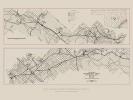
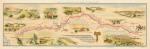
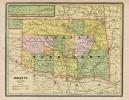
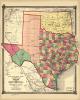
The Outlaw and Lawman Map of Oklahoma, Oklahoma Heritage Association, 1989.  Shows major events in Oklahoma relating to outlaws and lawman (OKMAP.0009A).


You might also like...

Bird's-eye view of Fort Reno, Oklahoma Territory, 1891
$10.00
Birds-Eye View of Tulsa, 1918
Birds-Eye View of Tulsa, 1918: 17'' X 27'' Print
$10.00
Raymer Map, Early 1900s
Raymer Map, Early 1900s: 24'' X 36'' and 11''X14'' Prints
$10.00
First official State of Oklahoma Map, 1907 (large)
First official State of Oklahoma Map, 1907 (large): 18'' X 34'' Print
$10.00
  • Store
  • What's New
  • Books
  • Maps
  • Mouse Pads
  • Photographs
  • Playing Cards
  • Puzzles
  • Research Orders
Contact the Store
Shipping Policies
Research Request Policies

Oklahoma History Center 800 Nazih Zuhdi Drive, Oklahoma City, OK 73105
Site Index | Contact Us | Privacy