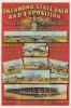
)
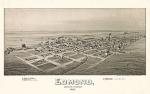
Bird's-eye view of Fort Reno, Oklahoma Territory, 1891
Thaddeus Mortimer Fowler
$10.00
Fort Reno had its origins as a temporary camp in July 1874 to protect the Cheyenne Arapaho Agency at Darlington following an Indian outbreak that led to the Red River War of 1874. The original military camp was enlarged and officially created as Fort Reno on July 15, 1875. It took its name from Gen. Jesse L. Reno, who had been killed at South Mountain, Maryland, during the Civil War.