)
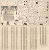
Blue Raymer Map, Early 1900s
$10.00
This hand-drawn map was crafted by Oklahoman Lester Raymer of Alva. In 1939 the Daughters of the American Revolution, who commissioned the work, donated the map to the Oklahoma Historical Society. On the map Raymer estimated the location of many historic sites, battles, roadways, and exploration routes.
(Image #Hismap.0001)