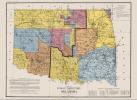
Contact Us | Press Room

Oklahoma Historical Society - Collect, Preserve, Share Skip to Content
  • Oklahoma History Center
    • About OHC
    • Visitor Info
    • Exhibits
    • Classes & Events
    • Education
    • Facility Use
    • Blog
    • CafĂ©
    • Shop
    • Contact Us
    • More...
  • Research Center
    • Oklahoma Resources
    • Genealogy
    • Records
    • Books
    • Indian Records
    • Photographs
    • Manuscripts
    • Newspapers
    • Maps
    • Oral Histories
    • Film & Video
    • Orders & Fees
    • Search Catalog
    • More...
  • Museums and Sites
    • Museums
    • Historic Homes
    • Military Sites
    • Affiliates
    • Historic Markers
    • More...
  • State Historic Preservation Office
    • National Register
    • Section 106
    • Tax Credits
    • Farm & Ranch
    • Special Events
    • HPRC
    • SHPO Staff
    • More...
  • Publications
    • Chronicles of Oklahoma
    • Encyclopedia
    • Books in Print
    • More...
  • About
    • History
    • Podcasts
    • Annual Meeting
    • OHS Extra! Newsletter
    • Board of Directors
    • Jobs Opportunities
    • Contact Us
    • Press Room
    • More...
  • Learn
  • Calendar
  • Support
    • Membership
    • Giving
    • Annual Giving
    • Naming Opportunities
    • Endowment/Planned Giving
    • Monogrammed Brick Locator
    • Volunteer
    • More...
none
Home > Store > Maps > Historic Maps > Chisholm Trail Map
Sign In or Register | View Cart | Checkout
Chisholm Trail Map

Chisholm Trail Map

Oklahoma State Highway Commission, 1933

$10.00

In its time, the Chisholm Trail was considered to be one of the wonders of the western world. Herds with as many as ten thousand cattle were driven from Texas over the trail to Kansas. The trail acquired its name from trader Jesse Chisholm, a part-Cherokee, who just before the Civil War had built a trading post in what is now western Oklahoma City. Eventually the Chisholm Trail would stretch eight hundred miles from South Texas to Fort Worth and on through Oklahoma to Kansas. The drives headed for Abilene from 1867 to 1871; later Newton and Wichita, Kansas became the end of the trail. The Cimarron cutoff on the north side of the Cimarron River allowed cattle to be driven to Dodge City, Kansas. From 1883 to 1887 herds headed up the trail to Caldwell, Kansas, making it the last great cow town on the trail.  From 1990 through 1997 Robert Klemme of Enid, Oklahoma, researched the route of the Chisholm Trail through Texas, Oklahoma, and Kansas and planned to place four hundred concrete markers along the route across Oklahoma. The four hundredth marker was placed on Wilshire Road near Yukon in September 1997. Klemme erected other markers in Brownsville, Texas, and Abilene, Kansas. At the end of the twentieth century the Chisholm Trail remained visible at many places, including a spot near Bison, in Garfield County, 1.5 miles south of U.S. 81 and one-third mile west on a county road.


You might also like...

State of Sequoyah
State of Sequoyah: 24'' X 18'' Print
$10.00
Raymer Map, Early 1900s
Raymer Map, Early 1900s: 24'' X 36'' and 11''X14'' Prints
$10.00
Indian Territory Map - 1892
$10.00
Texas Cattle Trail Map
$10.00
  • Store
  • What's New
  • Books
  • Maps
  • Mouse Pads
  • Photographs
  • Playing Cards
  • Puzzles
  • Research Orders
Contact the Store
Shipping Policies
Research Request Policies

Oklahoma History Center 800 Nazih Zuhdi Drive, Oklahoma City, OK 73105
Site Index | Contact Us | Privacy