Contact Us | Press Room

Oklahoma Historical Society - Collect, Preserve, Share Skip to Content
  • Oklahoma History Center
    • About OHC
    • Visitor Info
    • Exhibits
    • Classes & Events
    • Education
    • Facility Use
    • Blog
    • CafĂ©
    • Shop
    • Contact Us
    • More...
  • Research Center
    • Oklahoma Resources
    • Genealogy
    • Records
    • Books
    • Indian Records
    • Photographs
    • Manuscripts
    • Newspapers
    • Maps
    • Oral Histories
    • Film & Video
    • Orders & Fees
    • Search Catalog
    • More...
  • Museums and Sites
    • Museums
    • Historic Homes
    • Military Sites
    • Affiliates
    • Historic Markers
    • More...
  • State Historic Preservation Office
    • National Register
    • Section 106
    • Tax Credits
    • Farm & Ranch
    • Special Events
    • HPRC
    • SHPO Staff
    • More...
  • Publications
    • Chronicles of Oklahoma
    • Encyclopedia
    • Books in Print
    • More...
  • About
    • History
    • Podcasts
    • Annual Meeting
    • OHS Extra! Newsletter
    • Board of Directors
    • Jobs Opportunities
    • Contact Us
    • Press Room
    • More...
  • Learn
  • Calendar
  • Support
    • Membership
    • Giving
    • Annual Giving
    • Naming Opportunities
    • Endowment/Planned Giving
    • Monogrammed Brick Locator
    • Volunteer
    • More...
none
Home > Store > Maps > Historic Maps > Oklahoma State Ca...
Sign In or Register | View Cart | Checkout
Oklahoma State Capitol - 100th Anniversary

Oklahoma State Capitol - 100th Anniversary

$10.00

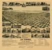
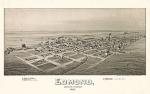
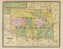
After many years of anticipation and various commissions, construction on the Oklahoma Capitol building began after a ground-breaking ceremony on July 20, 1914. William F. Harn and John J. Culbertson had donated land for the site. Prominently located at the intersection of Northeast Twenty-third Street and North Lincoln Boulevard in Oklahoma City, the six-story building is classically styled in the grand Beaux Arts tradition. Completed on June 30, 1917, the building has a concrete foundation with pink and gray granite, covering the raised basement and water table. The granite was quarried in Johnston County, Oklahoma. The walls above the foundation are clad with Bedford limestone. The reinforced concrete building is T-shaped with the primary north and south wings being shorter and terminating in projecting porticoes. The porticoes align with Lincoln Boulevard, which divides to go on either side of the Capitol. A square rotunda rises from the building's center. The exterior and interior are highly ornamented, including stone lions on the corners of the copper roof. In recognition of the building's historic significance, it is listed in the National Register of Historic Places (NR 76001572).


You might also like...

Home-Seekers Mecca Map - 1889
$10.00
1889 First 4th of July in OKC Poster
1889 First 4th of July in OKC Poster: 24'' X 36'' and 11' X 14 Prints
$10.00
Chisholm Trail Map
Chisholm Trail Map
$10.00
Military Map of the United States & Territories - 1861
$10.00
  • Store
  • What's New
  • Books
  • Maps
  • Mouse Pads
  • Photographs
  • Playing Cards
  • Puzzles
  • Research Orders
Contact the Store
Shipping Policies
Research Request Policies

Oklahoma History Center 800 Nazih Zuhdi Drive, Oklahoma City, OK 73105
Site Index | Contact Us | Privacy