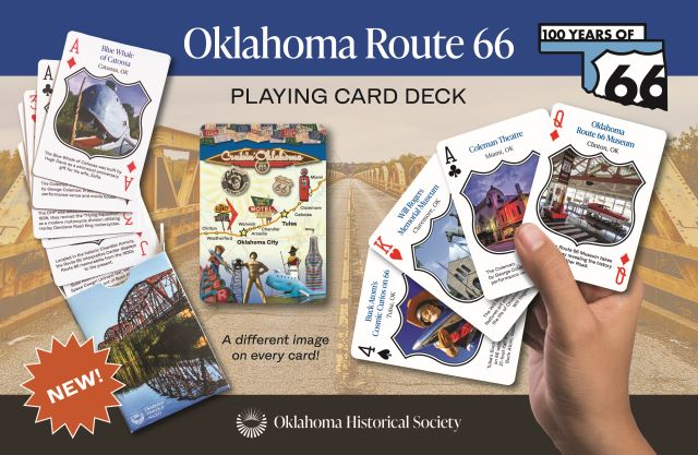
Contact Us | Press Room

Oklahoma Historical Society - Collect, Preserve, Share Skip to Content
  • Oklahoma History Center
    • About OHC
    • Visitor Info
    • Exhibits
    • Classes & Events
    • Education
    • Facility Use
    • Blog
    • CafĂ©
    • Shop
    • Contact Us
    • More...
  • Research Center
    • Oklahoma Resources
    • Genealogy
    • Records
    • Books
    • Indian Records
    • Photographs
    • Manuscripts
    • Newspapers
    • Maps
    • Oral Histories
    • Film & Video
    • Orders & Fees
    • Search Catalog
    • More...
  • Museums and Sites
    • Museums
    • Historic Homes
    • Military Sites
    • Affiliates
    • Historic Markers
    • More...
  • State Historic Preservation Office
    • National Register
    • Section 106
    • Tax Credits
    • Farm & Ranch
    • Special Events
    • HPRC
    • SHPO Staff
    • More...
  • Publications
    • Chronicles of Oklahoma
    • Encyclopedia
    • Books in Print
    • More...
  • About
    • History
    • Podcasts
    • Annual Meeting
    • OHS Extra! Newsletter
    • Board of Directors
    • Jobs Opportunities
    • Contact Us
    • Press Room
    • More...
  • Learn
  • Calendar
  • Support
    • Membership
    • Giving
    • Annual Giving
    • Naming Opportunities
    • Endowment/Planned Giving
    • Monogrammed Brick Locator
    • Volunteer
    • More...
none
Home > Store > Maps > Historic Maps > Indian Territory ...
Sign In or Register | View Cart | Checkout
Indian Territory During the 1889 Land Run

Indian Territory During the 1889 Land Run

$10.00

Indian Territory Map and descriptive text detailing the territory at the time of the 1889 Land Run. 

In the late nineteenth century the federal government began to assume more control over events transpiring in Indian country. In March 1889 a law established a federal court system based at Muskogee, assuming judicial authority and jurisdiction that had been exercised since the 1834 Trade Act by the Western District of Arkansas. The 1889 measure for the first time specified enclosed boundaries for the Indian Territory, now officially reduced to an area bounded by Texas on the south, Arkansas and Missouri on the east, Kansas on the north, and New Mexico Territory on the west.  Soon this area was reduced again when Oklahoma Territory was created from part of it by the Organic Act in May 1890. A governor was appointed, and a two-house territorial assembly and a judicial system were set up. A bona fide territory of the United States, Oklahoma Territory would be eligible for statehood if its population grew large enough and if its leaders followed the process prescribed by federal law. The Oklahoma Territory Organic Act even more closely defined Indian Territory, reducing it to slightly more than the eastern half of the present state. In the 1905 Sequoyah Convention, Indian leaders sought to bypass the territorial process and bring about separate statehood for Indian Territory. However, with the 1907 union of the Indian nations and Oklahoma Territory as the State of Oklahoma, a separate, Indian-dominated territory or state was no longer viable. During the twentieth century the generic term "Indian Territory" came to be used by historians, genealogists, and the public to represent the entire Oklahoma region during the prestatehood period.


You might also like...

Chisholm Trail Map
Chisholm Trail Map
$10.00
1912 Oklahoma State Fair Poster
$10.00
Indian Territory 1879
$10.00
Military Map of the United States & Territories - 1861
$10.00
  • Store
  • What's New
  • Books
  • Maps
  • Mouse Pads
  • Photographs
  • Playing Cards
  • Puzzles
  • Research Orders
Contact the Store
Shipping Policies
Research Request Policies

Oklahoma History Center 800 Nazih Zuhdi Drive, Oklahoma City, OK 73105
Site Index | Contact Us | Privacy