Contact Us | Press Room

Oklahoma Historical Society - Collect, Preserve, Share Skip to Content
  • Oklahoma History Center
    • About OHC
    • Visitor Info
    • Exhibits
    • Classes & Events
    • Education
    • Facility Use
    • Blog
    • CafĂ©
    • Shop
    • Contact Us
    • More...
  • Research Center
    • Oklahoma Resources
    • Genealogy
    • Records
    • Books
    • Indian Records
    • Photographs
    • Manuscripts
    • Newspapers
    • Maps
    • Oral Histories
    • Film & Video
    • Orders & Fees
    • Search Catalog
    • More...
  • Museums & Sites
    • Museums
    • Historic Homes
    • Military Sites
    • Affiliates
    • Historic Markers
    • More...
  • State Historic Preservation Office
    • National Register
    • Section 106
    • Tax Credits
    • Farm & Ranch
    • Special Events
    • HPRC
    • SHPO Staff
    • More...
  • Publications
    • Chronicles of Oklahoma
    • Encyclopedia
    • Books in Print
    • More...
  • About
    • History
    • Podcasts
    • Annual Meeting
    • OHS Extra! Newsletter
    • Board of Directors
    • Jobs Opportunities
    • Contact Us
    • Press Room
    • More...
  • Education
  • Calendar
  • Support OHS
    • Membership
    • Giving
    • Annual Giving
    • Naming Opportunities
    • Endowment/Planned Giving
    • Monogrammed Brick Locator
    • Volunteer
    • More...
none
Home > Store > Maps > Historic Maps > Greatest Horse Ra...
Sign In or Register | View Cart | Checkout
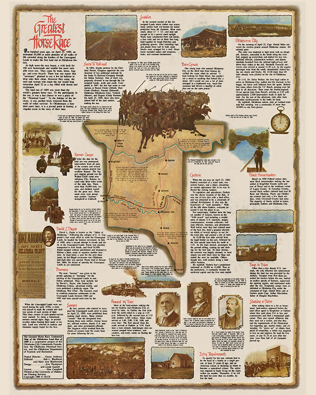
Greatest Horse Race - A Centennial Map of the 1889 Oklahoma Land Run

Greatest Horse Race - A Centennial Map of the 1889 Oklahoma Land Run

$10.00

The Land Run of 1889, although not without precedent in the history of the West, began the disposal of the federal public domain in Oklahoma. The legal basis for opening the Oklahoma District, now called the Unassigned Lands, came in 1889 when, in the U.S. Congress, Illinois Rep. William Springer amended the Indian Appropriations Bill to authorize Pres. Benjamin Harrison to proclaim the two-million-acre region open for settlement. Under the provisions of the Homestead Act of 1862, a legal settler could claim 160 acres of public land, and those who lived on and improved the claim for five years could receive a title.


You might also like...

U.S. Indian Reservations 1893
U.S. Indian Reservations 1893: 26'' x 19''
$10.00
The Outlaw and Lawman Map of Oklahoma
$10.00
Votes For Women Map
Votes For Women Map
$10.00
Railroad Map, Oklahoma, 1909
Railroad Map, Oklahoma, 1909: 24'' X 42'' Print
$10.00
  • Store
  • What's New
  • Maps
  • Photographs
  • Playing Cards
  • Puzzles
  • Research Orders
Contact the Store
Shipping Policies
Research Request Policies

Oklahoma History Center 800 Nazih Zuhdi Drive, Oklahoma City, OK 73105
Site Index | Contact Us | Privacy